Airspace classes, when ATC authorization is needed, and reading VFR sectional chart excerpts from the FAA testing supplement. 13 free questions with answers and explanations.
Practice questions written from official FAA publications. They are not questions from the FAA knowledge test.
1.Airspace
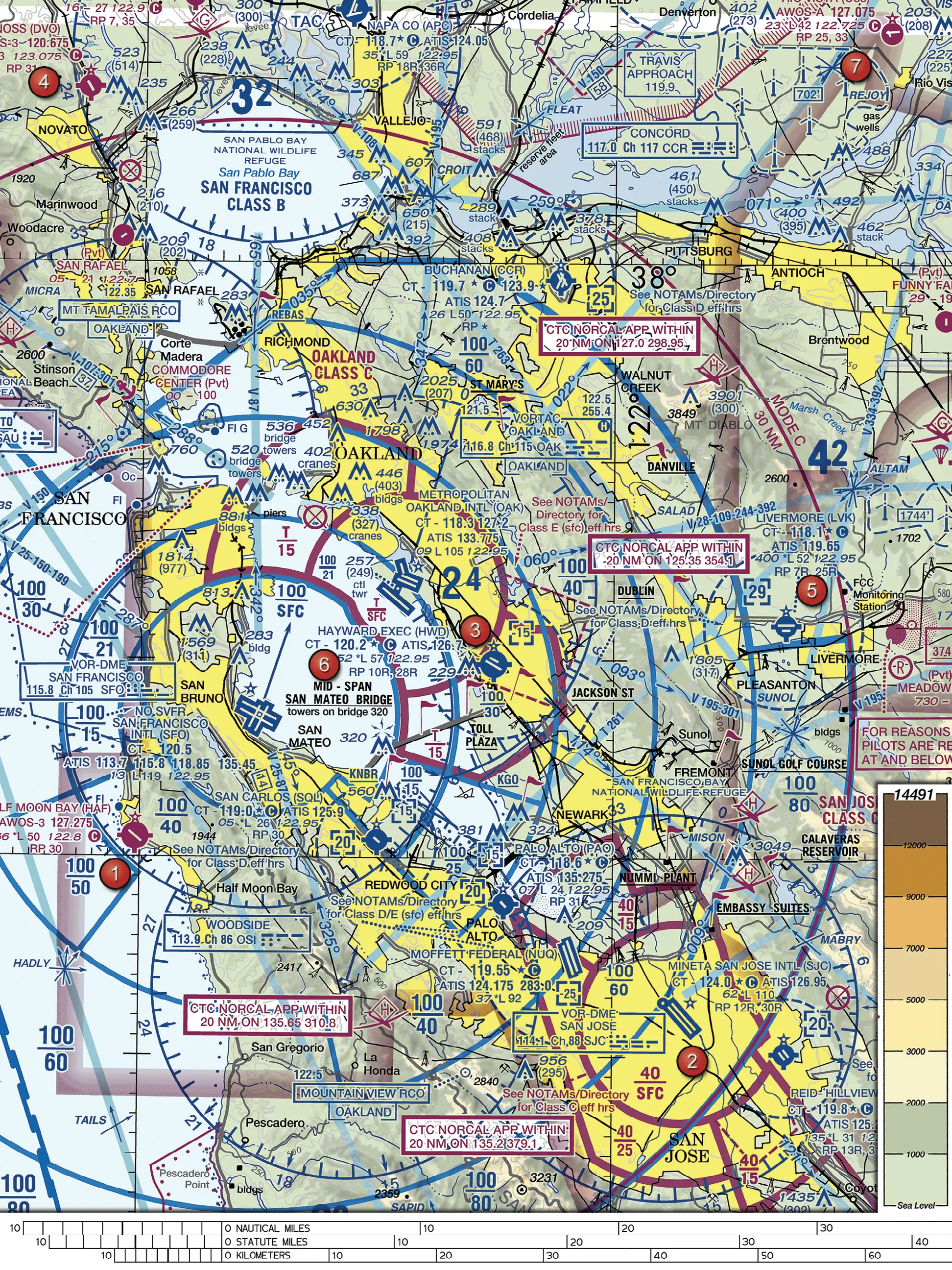
(Refer to Figure 70.) Over the bay just south-east of the word 'piers', a sector of the Oakland Class C is labeled with a magenta T over 15. What does the T indicate?
Figure 70, FAA Airman Knowledge Testing Supplement (FAA-CT-8080-2H). Open full size to zoom. Not for navigation.
AThe sector is a Terminal Radar Service Area rather than Class C airspace
BThe Class C in that sector is temporary and active only when announced by NOTAM
CThe Class C extends up to, but not including, the floor of the overlying Class B airspace
Show answer and explanation
Correct answer: C. The Class C extends up to, but not including, the floor of the overlying Class B airspace
Class C sector altitudes are shown in magenta as ceiling over floor. A ceiling of T means the Class C goes up to, but not including, the floor of the overlying Class B airspace; here the floor is 1,500 feet MSL.
A. Incorrect. TRSAs are shown with screened black lines and black altitude figures; this magenta label is a Class C sector ceiling.
B. Incorrect. T is a ceiling value, not a note about temporary activation.
C. Correct. A Class C ceiling value of T means the ceiling is to, but not including, the floor of the overlying Class B airspace.
Marked on Figure 70: Oakland Class C sector T/15 south-east of 'piers'.
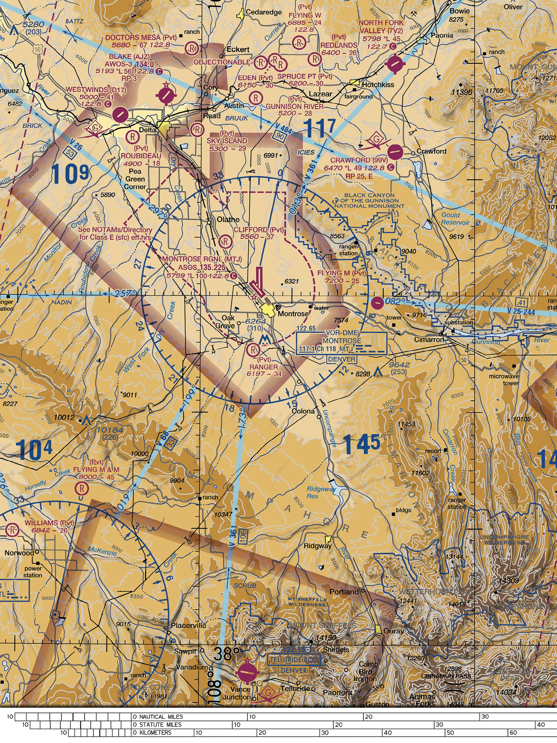
(Refer to Figure 80.) Just southwest of Westwinds Airport (D17), near Delta, a magenta flag symbol containing the letter G is printed. What should a remote pilot planning a flight there expect?
Figure 80, FAA Airman Knowledge Testing Supplement (FAA-CT-8080-2H). Open full size to zoom. Not for navigation.
AHang glider activity
BGlider operations
CUltralight activity
Show answer and explanation
Correct answer: B. Glider operations
The sectional legend identifies the magenta G symbol as Glider Operations, so a remote pilot planning a flight near Westwinds and Delta should expect gliders in the area.
A. Incorrect. Hang glider activity has its own legend symbol; the G symbol is used for glider operations.
B. Correct. The sectional legend identifies the G symbol as Glider Operations.
C. Incorrect. Ultralight activity is shown with a different legend symbol, not a G.
Marked on Figure 80: Glider symbol near Westwinds (D17).
Source
FAA-CT-8080-2H Airman Knowledge Testing Supplement, Legend 1, Airport Traffic Service and Airspace Information
How is a temporary flight restriction (TFR) put in place, and what should a remote pilot do about TFRs before each flight?
AIt is printed on the current sectional chart; check the chart legend.
BIt is designated by a flight data center (FDC) NOTAM; check NOTAMs before each flight.
CIt is listed in the Chart Supplement U.S.; checking it once per edition is enough.
Show answer and explanation
Correct answer: B. It is designated by a flight data center (FDC) NOTAM; check NOTAMs before each flight.
A TFR is designated by a flight data center (FDC) NOTAM. AC 107-2A tells the remote PIC to check for NOTAMs before each flight to determine whether any airspace restrictions apply.
A. Incorrect. Wrong. A TFR is designated by an FDC NOTAM, not by a chart, so the pilot must check NOTAMs.
B. Correct. An FDC NOTAM designates a TFR, and the remote PIC must check NOTAMs before each flight.
C. Incorrect. Wrong. A TFR is designated by an FDC NOTAM, and NOTAMs must be checked before each flight.
Source
FAA-G-8082-22 Remote Pilot – sUAS Study Guide, Chapter 2, Temporary Flight Restrictions (TFR)
AC 107-2A Small Unmanned Aircraft Systems (sUAS), 5.10.3
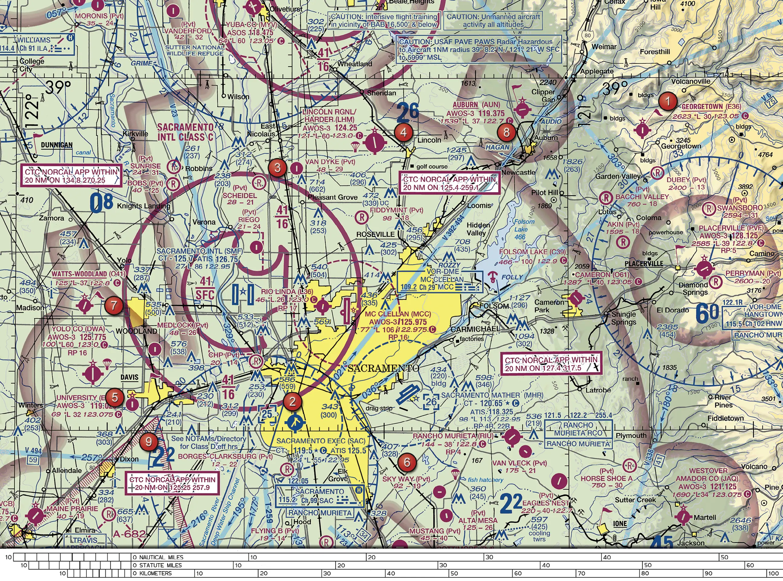
(Refer to Figure 71.) Near Pleasant Grove, east-northeast of Sacramento International, the Class C sector is labeled 41 over 16. The ground there is about 50 feet MSL. A remote pilot flies at 400 feet AGL. Where is the aircraft relative to the Class C airspace?
Figure 71, FAA Airman Knowledge Testing Supplement (FAA-CT-8080-2H). Open full size to zoom. Not for navigation.
AInside it, because everything within the outer Class C circle begins at the surface
BInside it, because the aircraft is below the Class C ceiling of 4,100 feet MSL
CBelow it, because the Class C floor in this sector is 1,600 feet MSL
Show answer and explanation
Correct answer: C. Below it, because the Class C floor in this sector is 1,600 feet MSL
Class C figures show the MSL ceiling over the MSL floor with the last two zeros removed. 41 over 16 is 1,600 to 4,100 feet MSL. The aircraft at about 450 feet MSL is below this shelf, so it is not in the Class C airspace.
A. Incorrect. Only sectors labeled SFC begin at the surface. This sector has a floor of 16, which is 1,600 feet MSL.
B. Incorrect. Being below the ceiling is not enough. The aircraft must also be above the floor, which here is 1,600 feet MSL.
C. Correct. 41 over 16 means Class C from 1,600 to 4,100 feet MSL. At about 450 feet MSL (50 + 400) the aircraft is under the shelf.
Marked on Figure 71: Sacramento Intl Class C shelf 41/16 near Pleasant Grove.
Source
FAA Chart Users' Guide (Aeronautical Chart User's Guide), complete, VFR Terms and Symbols, Airspace: Class C
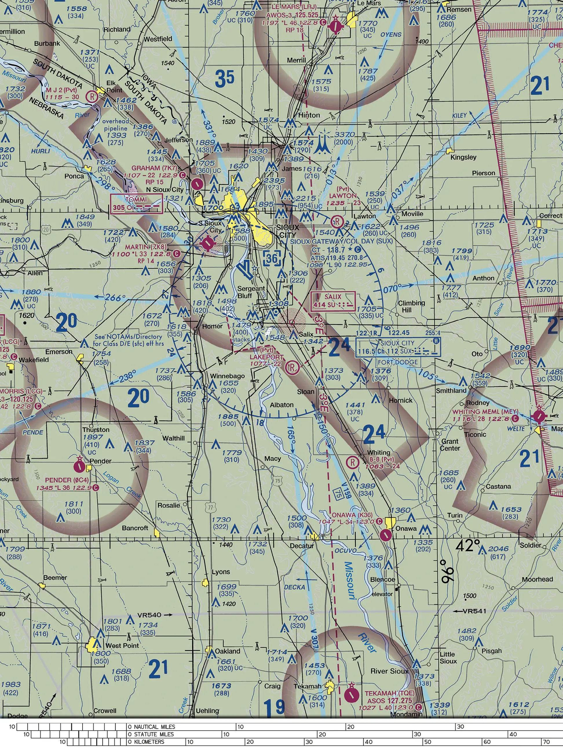
(Refer to Figure 78.) North-west of Hornick, an obstacle is charted 1376 over (309). A remote pilot flies the small UA at 400 feet AGL next to it over flat ground. How does the UA's height compare with the top of the obstacle?
Figure 78, FAA Airman Knowledge Testing Supplement (FAA-CT-8080-2H). Open full size to zoom. Not for navigation.
AAbout 91 feet above the top
BAbout 976 feet below the top
CAbout 709 feet above the top
Show answer and explanation
Correct answer: A. About 91 feet above the top
The label gives the top at 1,376 feet MSL and, in parentheses, the height of 309 feet above ground. Both the UA's altitude and the 309 are measured from the same flat ground, so the UA is 400 - 309 = 91 feet above the obstacle's top.
A. Correct. The obstacle is 309 feet above the ground, so a UA at 400 feet AGL is 400 - 309 = 91 feet above its top.
B. Incorrect. This subtracts an AGL altitude from the MSL top elevation (1,376 - 400); the two values use different references.
C. Incorrect. This adds the obstacle height to the flight altitude (400 + 309) instead of comparing them.
Marked on Figure 78: Obstacle 1376 (309) north-west of Hornick.
Source
FAA Chart Users' Guide (Aeronautical Chart User's Guide), complete, VFR Terms and Symbols, Land Features (Terrain) and Obstructions
FAA Chart Users' Guide (Aeronautical Chart User's Guide), complete, VFR Terms and Symbols, Land Features (Terrain) and Obstructions
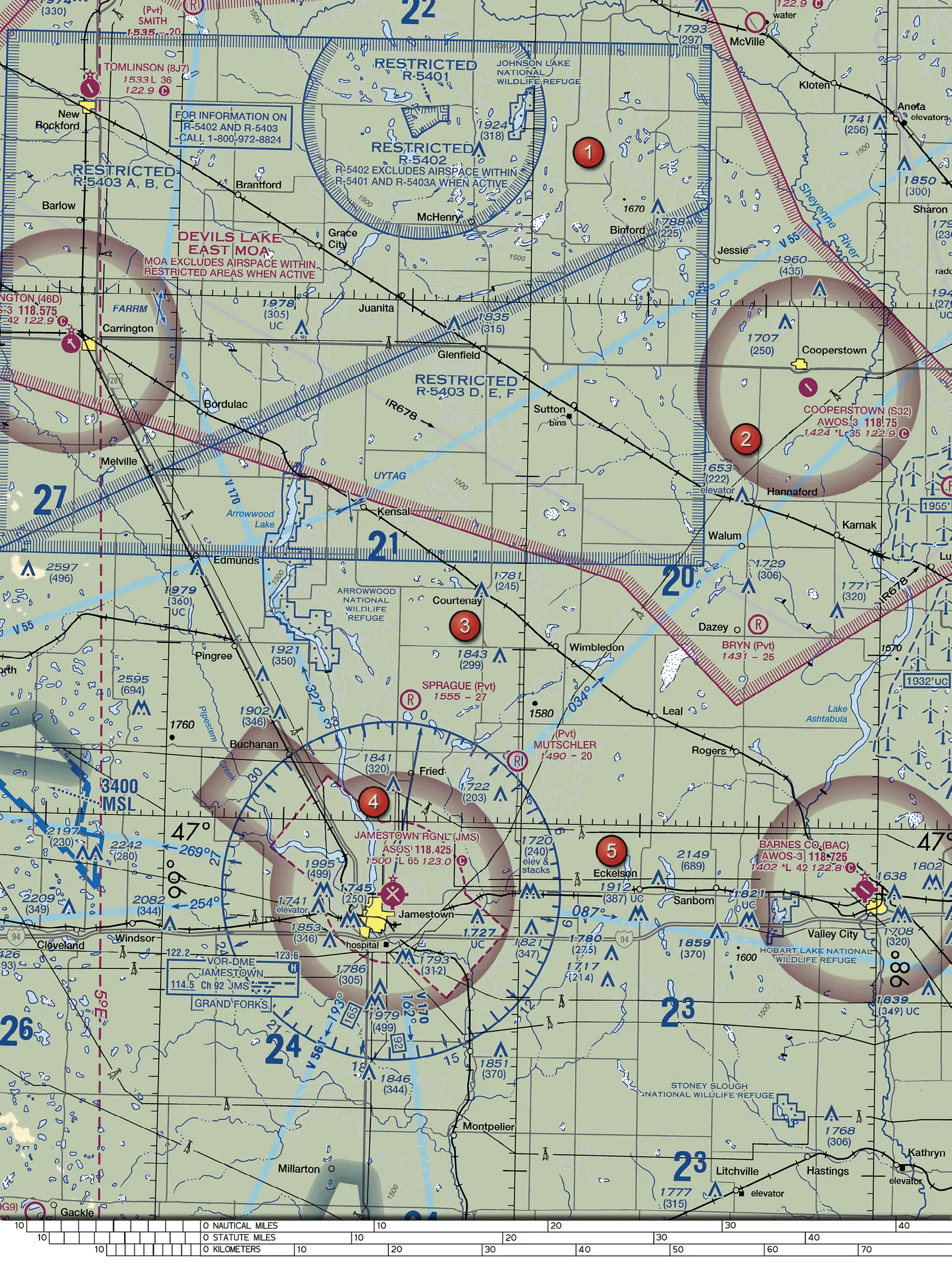
(Refer to Figure 26.) A remote pilot is hired to photograph hangars at Jamestown Regional Airport (JMS), just south of area 4, from 150 feet AGL. The airport lies inside a dashed magenta line. What does part 107 require for this flight?
Figure 26, FAA Airman Knowledge Testing Supplement (FAA-CT-8080-2H). Open full size to zoom. Not for navigation.
APrior ATC authorization, because the dashed magenta line marks the Class E surface area for the airport
BNo ATC authorization, because the dashed magenta line marks Class G airspace up to 700 feet AGL
CNo ATC authorization, because part 107 never requires authorization in Class E airspace
Show answer and explanation
Correct answer: A. Prior ATC authorization, because the dashed magenta line marks the Class E surface area for the airport
The dashed magenta line around Jamestown Regional shows a Class E surface area. Section 107.41 requires prior ATC authorization to operate within the lateral boundaries of a Class E surface area designated for an airport, even at 150 feet AGL.
A. Correct. A dashed magenta line is the chart symbol for Class E surface airspace, and §107.41 requires prior ATC authorization within the lateral boundaries of a Class E surface area designated for an airport.
B. Incorrect. A Class E floor of 700 feet AGL is shown by a magenta vignette, not a dashed line. The dashed magenta line marks Class E airspace that begins at the surface.
C. Incorrect. §107.41 specifically requires prior ATC authorization within the lateral boundaries of the surface area of Class E airspace designated for an airport.
Marked on Figure 26: Jamestown Rgnl (JMS).
Source
FAA Chart Users' Guide (Aeronautical Chart User's Guide), complete, VFR Terms and Symbols, Airspace: Class E Surface (SFC)
In which of the following Class E airspace locations does 14 CFR part 107 require prior ATC authorization for a small UA flight?
AAny Class E airspace, regardless of where its floor begins.
BAnywhere beneath a Federal Airway shown as a blue line on a sectional chart.
CWithin the lateral boundaries of the Class E surface area designated for an airport.
Show answer and explanation
Correct answer: C. Within the lateral boundaries of the Class E surface area designated for an airport.
§107.41 lists Class B, C and D airspace plus the lateral boundaries of the surface area of Class E airspace designated for an airport. Elsewhere in Class E, a remote pilot in most cases does not need ATC authorization.
A. Incorrect. Wrong. The study guide notes that in most cases a remote pilot will not need ATC authorization to operate in Class E airspace; §107.41 names only the surface area designated for an airport.
B. Incorrect. Wrong. Federal Airways start at 1,200 feet AGL, and §107.41 does not list airways as requiring authorization.
C. Correct. §107.41 requires prior ATC authorization within the lateral boundaries of the surface area of Class E airspace designated for an airport.
Source
14 CFR Part 107 (eCFR), §107.41
FAA-G-8082-22 Remote Pilot – sUAS Study Guide, Chapter 2, Class E Airspace
FAA-G-8082-22 Remote Pilot – sUAS Study Guide, Chapter 2, Class E Airspace
(Refer to Figure 71.) Near the bottom of the figure, south-east of Eagles Nest (Pvt), an obstacle group is charted 597 over (425) with a short descriptive label. On a calm, cold morning, a remote pilot will survey a field next to it at 300 feet AGL and sees no plume above the structures. What should the pilot assume?
Figure 71, FAA Airman Knowledge Testing Supplement (FAA-CT-8080-2H). Open full size to zoom. Not for navigation.
AThey are cooling towers; an invisible exhaust plume may still cause turbulence, so the airspace near them needs caution
BThey are cooling towers; with no visible plume they are not operating, so only a collision with the towers matters
CThey are wind turbines; only their unlit blade tips, which can reach 300 feet above the lights, need extra clearance
Show answer and explanation
Correct answer: A. They are cooling towers; an invisible exhaust plume may still cause turbulence, so the airspace near them needs caution
The obstacle group 597 (425) is labeled cooling twrs. Cooling towers emit exhaust plumes that can cause turbulence and vertical shear. A plume may be invisible, and stacks without a visible plume may still be operating, so the remote pilot should treat the airspace near them with caution, especially in calm, cold air at low altitude.
A. Correct. The label reads cooling twrs. The AIM says stacks without visible plumes may still be in full operation and the airspace nearby should be treated with caution; the hazard is greatest at low altitude in calm, cold air.
B. Incorrect. Wrong. The AIM warns that a plume may have invisible characteristics and that stacks without visible plumes may still be in full operation.
C. Incorrect. Wrong. The chart labels this group cooling twrs and shows no wind turbine symbols or wind farm outline there.
Marked on Figure 71: Cooling towers 597 (425) south-east of Eagles Nest.
Source
Aeronautical Information Manual (AIM), Basic with Changes 1, 2 and 3, 7-6-16b
Aeronautical Information Manual (AIM), Basic with Changes 1, 2 and 3, 7-6-16a
(Refer to Figure 26.) A remote pilot will film a runway inspection at 100 feet AGL on the grounds of Cooperstown Airport (S32), north-east of area 2, inside the faded magenta ring. No dashed line surrounds the airport. According to the AIM, what does this on-airport flight require?
Figure 26, FAA Airman Knowledge Testing Supplement (FAA-CT-8080-2H). Open full size to zoom. Not for navigation.
APrior ATC authorization through LAANC, because Class E airspace begins at the surface at this airport
BCoordination with the airport operator; no ATC authorization is needed in this Class G airspace
CA request submitted through DroneZone, as the AIM requires for every on-airport operation
Show answer and explanation
Correct answer: B. Coordination with the airport operator; no ATC authorization is needed in this Class G airspace
Cooperstown sits in a magenta vignette, so controlled airspace (Class E) begins 700 feet above the ground, and no dashed line marks a surface area. At 100 feet AGL the small UA is in Class G, which remote pilots may generally use without special permission, so neither LAANC nor a DroneZone request applies. Because the flight is on the airport itself, the current AIM (11-7-1b) says it requires coordination with the airport operator. AC 107-2A 5.10.1 (2021) says that outside controlled airspace no notification or authorization is necessary at or near an airport; for operations on the airport, the newer AIM 11-7-1b is the current guidance, which is why this question asks what the AIM says.
A. Incorrect. The faded magenta ring marks Class E beginning 700 feet above the ground, and no dashed surface-area line surrounds the airport, so at 100 feet AGL the flight is in Class G, where no ATC authorization is needed.
B. Correct. The AIM says sUAS operations on airports require coordination with the airport operator (and other parties where applicable). The airspace at 100 feet AGL is Class G, so no ATC authorization is needed.
C. Incorrect. The AIM requires DroneZone requests for on-airport operations within controlled airspace. This flight is in uncontrolled Class G airspace.
Marked on Figure 26: Cooperstown Airport (S32) and its magenta vignette.
Source
Aeronautical Information Manual (AIM), Basic with Changes 1, 2 and 3, 11-7-1b
Aeronautical Information Manual (AIM), Basic with Changes 1, 2 and 3, 11-7-1b
Aeronautical Information Manual (AIM), Basic with Changes 1, 2 and 3, 11-4-6a
A chart shows a VFR corridor through Class B airspace above a riverfront site. A remote pilot reasons that, because manned aircraft fly the corridor without an ATC clearance, flying the small UA at 200 feet AGL below it needs no ATC authorization. Why is this reasoning flawed?
AA VFR corridor is open only to aircraft with an operating transponder
BA VFR corridor extends to the surface, but only manned aircraft may use it
CA VFR corridor is surrounded on all sides by Class B airspace and does not extend down to the surface
Show answer and explanation
Correct answer: C. A VFR corridor is surrounded on all sides by Class B airspace and does not extend down to the surface
A VFR corridor is airspace through Class B airspace, with defined vertical and lateral boundaries, in which aircraft may operate without an ATC clearance. It is surrounded on all sides by Class B airspace and does not reach the surface like a VFR Flyway. The corridor therefore gives no basis for a low-level flight below it; the remote pilot must determine the airspace at the flight altitude, and §107.41 requires authorization in Class B.
A. Incorrect. Wrong. The AIM says aircraft may operate in a corridor without an ATC clearance or communication; it states no transponder condition for corridors.
B. Incorrect. Wrong. The AIM says a corridor does not extend down to the surface.
C. Correct. The corridor is a hole through Class B with defined vertical and lateral limits, surrounded on all sides by Class B, so it does not create a clearance-free gap at ground level.
Source
Aeronautical Information Manual (AIM), Basic with Changes 1, 2 and 3, 3-5-5b2
Aeronautical Information Manual (AIM), Basic with Changes 1, 2 and 3, 3-5-5b1
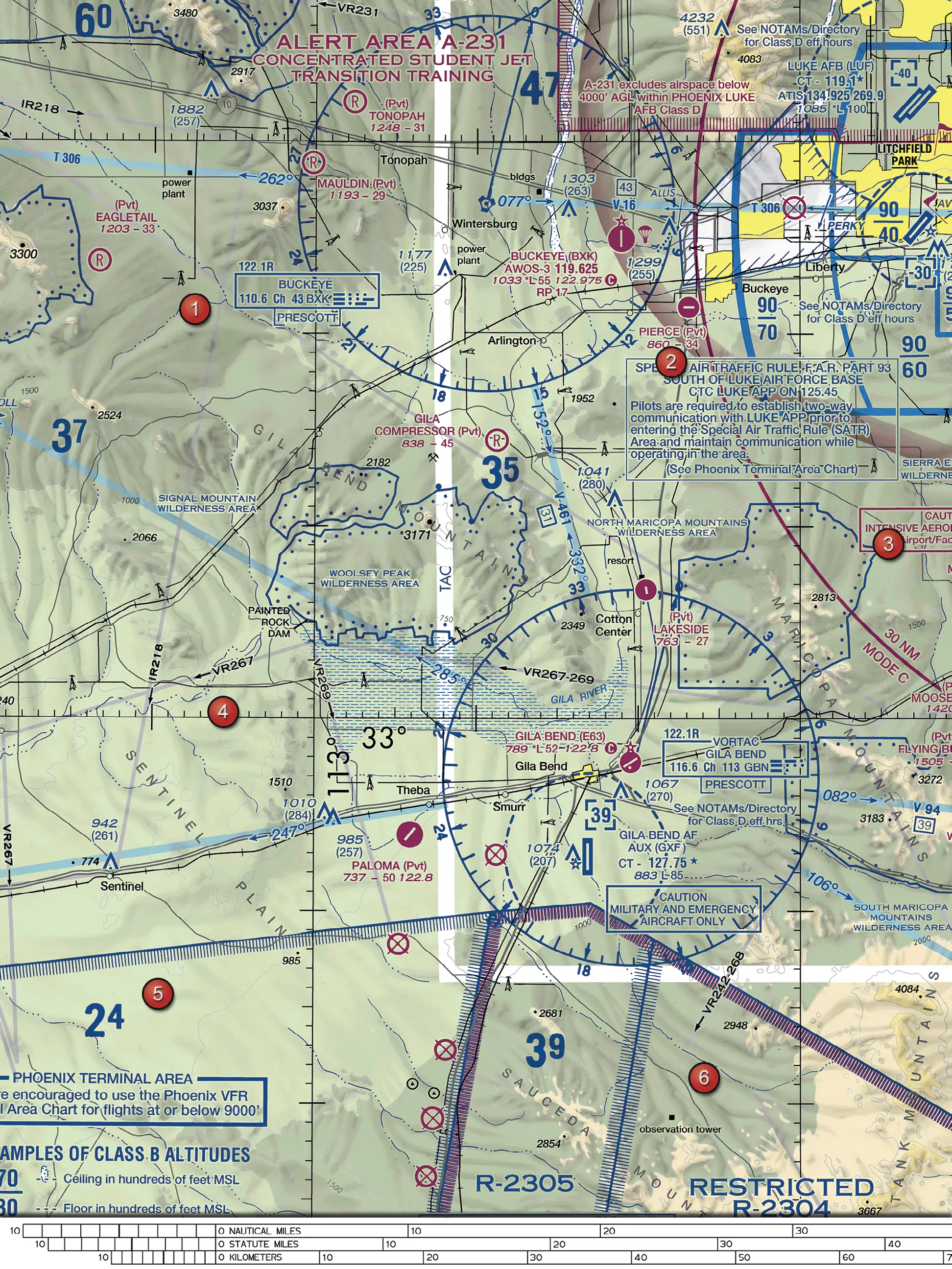
(Refer to Figure 75.) Near the bottom of the figure, south of Gila Bend, a restricted area is labeled R-2305. Where on the sectional chart should a remote pilot look for this area's altitudes, times of use, and controlling agency?
Figure 75, FAA Airman Knowledge Testing Supplement (FAA-CT-8080-2H). Open full size to zoom. Not for navigation.
AIn the label printed inside the area boundary, next to R-2305
BIn the special use airspace tabulation printed on the chart
CNowhere on the chart; restricted area details are published only by NOTAM
Show answer and explanation
Correct answer: B. In the special use airspace tabulation printed on the chart
On the sectional, the area itself is marked only with its type and number. The special use airspace tabulation on the chart lists prohibited, restricted and warning areas numerically, with altitude, time of use and the controlling agency or contact facility and frequency.
A. Incorrect. The label inside or next to the area only identifies its type and name or number.
B. Correct. Restricted areas are listed numerically in the tabulation, with altitude, time of use and the controlling agency or contact facility.
C. Incorrect. The sectional's special use airspace tabulation gives altitude, time of use and the controlling agency.
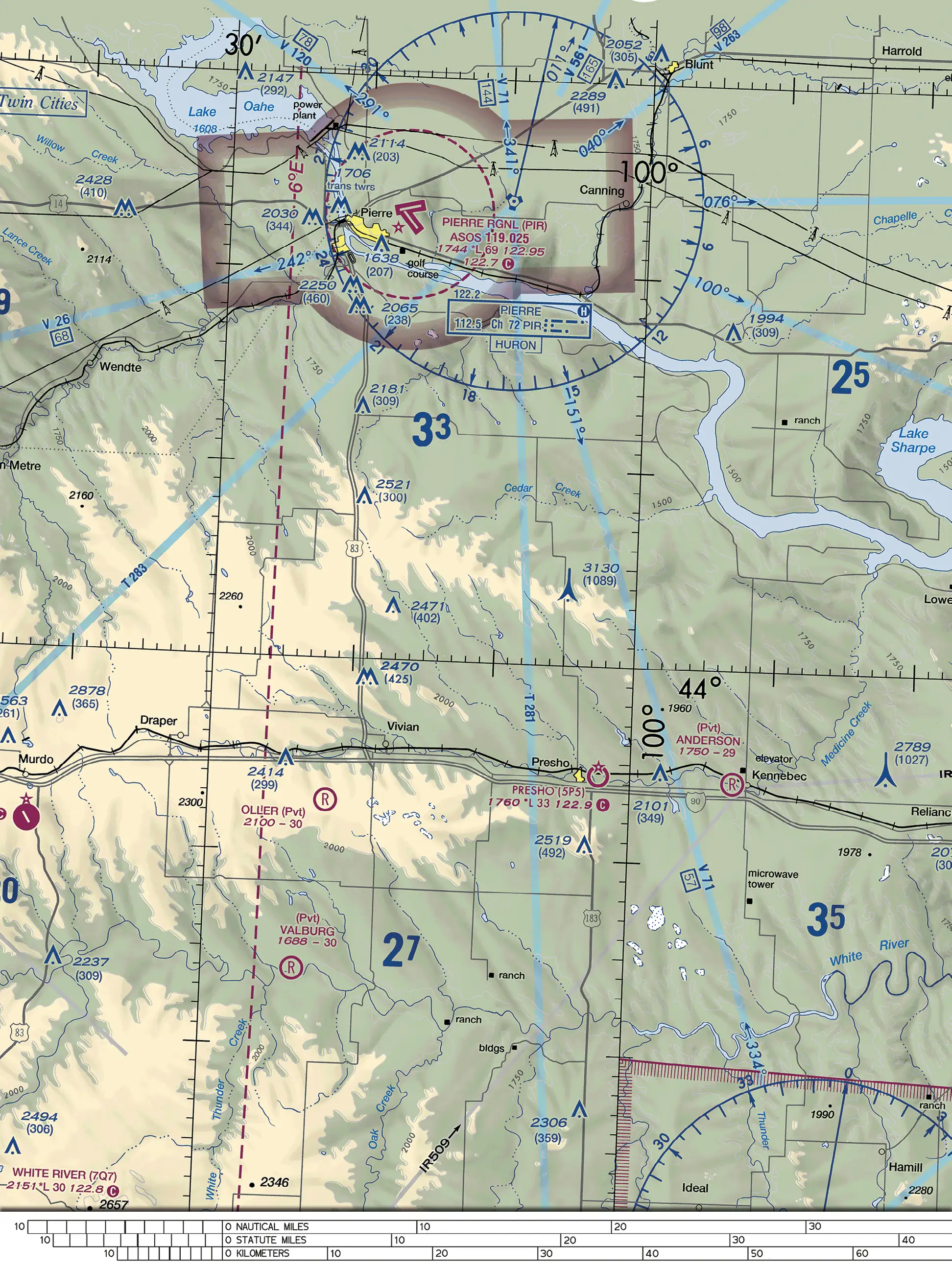
(Refer to Figure 76.) A remote pilot will photograph farmland near the obstacle charted as 3130 (1089), south of Cedar Creek and east of highway 83. It is a guyed antenna tower. What minimum horizontal distance from the tower is recommended?
Figure 76, FAA Airman Knowledge Testing Supplement (FAA-CT-8080-2H). Open full size to zoom. Not for navigation.
AAt least 1,089 feet, equal to the tower's height above ground
BAt least 500 feet
CAt least 2,000 feet
Show answer and explanation
Correct answer: C. At least 2,000 feet
Guy wires supporting skeletal structures are very hard to see and can extend about 1,500 feet horizontally from the structure. The study guide therefore advises avoiding all skeletal structures horizontally by at least 2,000 feet.
A. Incorrect. The recommended distance comes from how far guy wires can extend (about 1,500 feet), not from the tower's height; skeletal structures should be avoided horizontally by at least 2,000 feet.
B. Incorrect. Guy wires can extend about 1,500 feet from a structure, so 500 feet could put the aircraft among the wires.
C. Correct. Guy wires can extend about 1,500 feet horizontally, so skeletal structures should be avoided horizontally by at least 2,000 feet.
Marked on Figure 76: Obstacle 3130 (1089).
Source
FAA-G-8082-22 Remote Pilot – sUAS Study Guide, Chapter 11, Antenna Towers
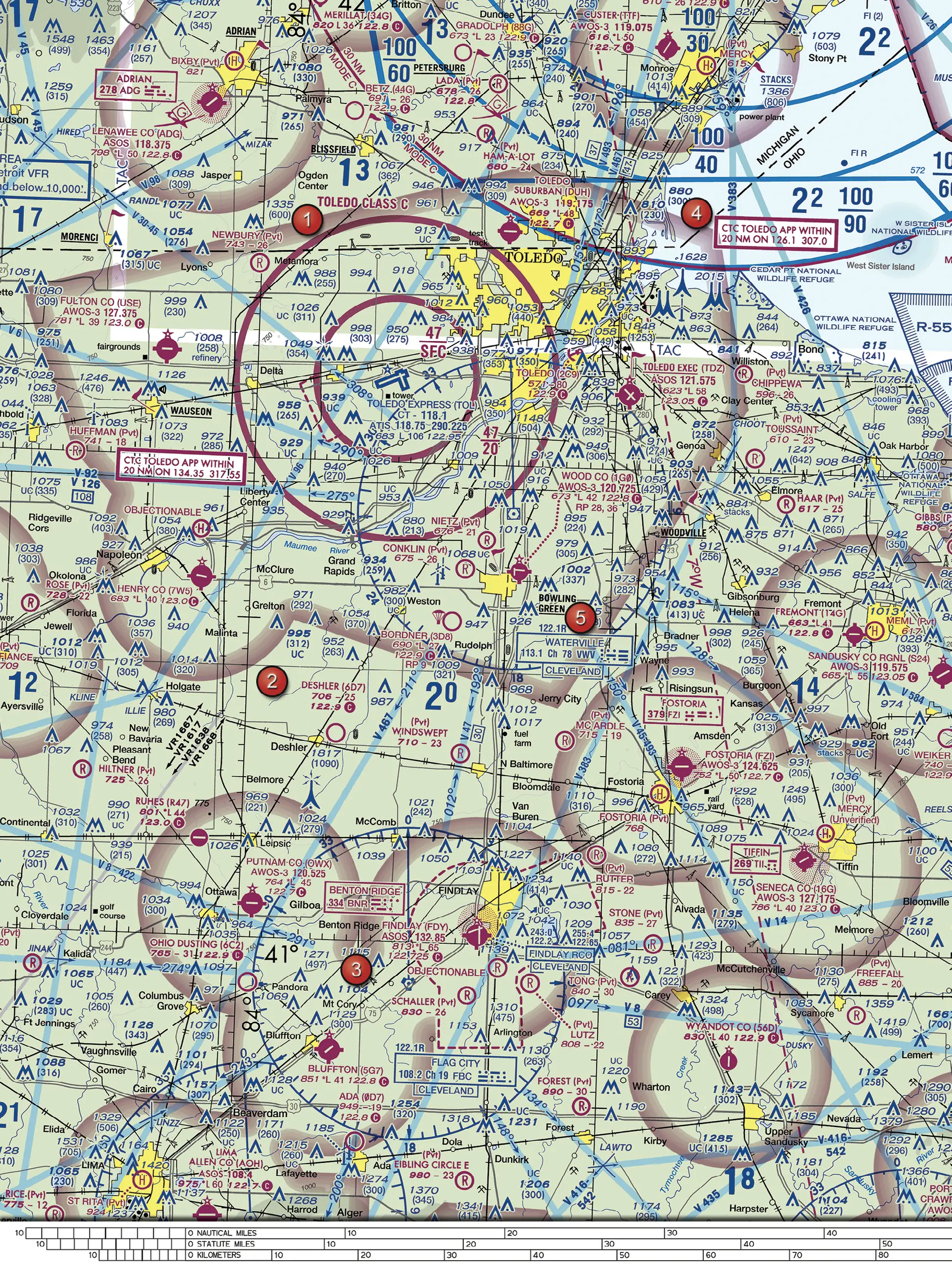
(Refer to Figure 59.) South-east of Metamora, inside the outer magenta circle of the Toledo Class C, an obstacle is charted 988 over (255). A remote pilot inspecting it keeps the small UA within 400 feet of it. What is the highest altitude allowed, and is the UA inside the Class C there?
Figure 59, FAA Airman Knowledge Testing Supplement (FAA-CT-8080-2H). Open full size to zoom. Not for navigation.
A1,388 feet MSL, which is below the 2,000-foot MSL floor of this Class C sector
B400 feet AGL, because the structure allowance does not apply beneath a Class C shelf
C1,388 feet MSL, but the UA is in Class C from the surface because it is inside the outer circle
Show answer and explanation
Correct answer: A. 1,388 feet MSL, which is below the 2,000-foot MSL floor of this Class C sector
The obstacle's top is 988 feet MSL and its height is 255 feet AGL. Within a 400-foot radius, part 107 allows flight up to 400 feet above the structure's top: 988 + 400 = 1,388 feet MSL. The outer Class C sector is labeled 47 over 20 (ceiling 4,700, floor 2,000 feet MSL), so the UA stays below the Class C.
A. Correct. Within 400 feet of the structure the UA may climb to 988 + 400 = 1,388 feet MSL. The outer sector is labeled 47 over 20, so Class C starts at 2,000 feet MSL there.
B. Incorrect. The part 107 allowance to fly up to 400 feet above a structure has no exception for airspace beneath a Class C shelf.
C. Incorrect. Only the inner circle (47 over SFC) starts at the surface. Between the circles the floor is 2,000 feet MSL.
Marked on Figure 59: Obstacle 988 (255) south-east of Metamora.
Marked on Figure 59: Toledo Class C labels 47/SFC and 47/20.
Source
FAA Chart Users' Guide (Aeronautical Chart User's Guide), complete, VFR Chart Symbology, Airspace Information, Class C
FAA Chart Users' Guide (Aeronautical Chart User's Guide), complete, VFR Terms and Symbols, Land Features (Terrain) and Obstructions
Remote Pilot Ace has topic practice, full 65-question mock exams in the test format, zoomable figures and an explanation with its source for every answer. Free to start.
Coming soon to the App Store and Google Play. About the app